The Site
Whilst there are several identifiable development constraints across the site, there are few technical surprises.
Transport
The proposed development is expected to lead to only a small increase in traffic of 4.5%. This increase can be comfortably accommodated on the existing local road network. Following discussions with Devon County Council Highways, a new and improved access to the site will be provided. This will include a dedicated right-turn lane from Sidmouth Road (A3052), helping traffic to enter and leave the site safely. Improvements will also be made for people walking and cycling. New and upgraded footway and cycleway connections will link the site to the existing paths near the Westpoint showground and to the new Marlcombe town centre, making it easier and safer to travel on foot or by bike.
Overall, the proposals meet national highway and transport standards and have been designed to ensure that the development operates safely without adversely affecting the local road network. For local residents, this means traffic impacts will be limited, access will be safer than at present, and walking and cycling connections in the area will be improved.
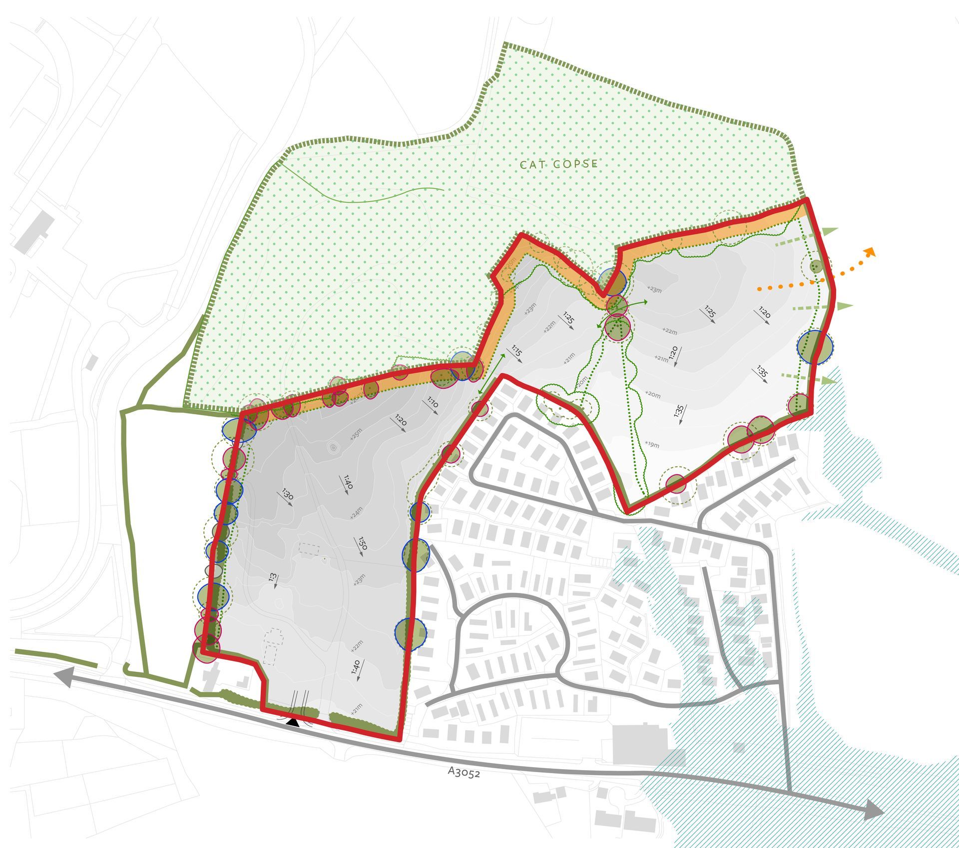
Ecology
The site comprises a mosaic of predominantly semi-improved grassland and regularly cut poor semi-improved grassland, with ecological interest largely confined to the network of boundary hedgerows, hedgerow trees and areas of scrub. A small ephemeral pond is present within the north-western part of the site, with a further pond located within the adjacent woodland to the north-east.
The majority of on-site habitats are considered to be of limited ecological value due to a lack of botanical diversity and frequent management, although boundary features provide connectivity and potential for protected species. Various ecological surveys have been undertaken, with a bat night roost recorded within a derelict building and also a tree bat roost. A ‘good' slow-worm population and ‘low’ grass snake population were recorded and largely at boundary features. No hazel dormice were recorded and both ponds tested negative for great crested newt eDNA. Appropriate mitigation and enhancements have been proposed with opportunities to deliver measurable biodiversity improvements.
Flood risk and drainage
The proposed drainage strategy is to restrict surface water runoff to greenfield rates and manage flows using Sustainable Drainage Systems (SuDS), with the site split into two catchments due to topography. Infiltration testing indicates soakaways are not suitable, so surface water is proposed to discharge to nearby watercourses via sewer requisition, with on-site attenuation provided through attenuation basins (and below-ground attenuation where required). The system has been designed for the 1 in 100 year storm event plus 45% climate change allowance (and 10% urban creep), ensuring the development does not increase flood risk to third parties.
Trees and hedgerows
The site is made up of three fields bordered by native hedgerows with mature trees in the hedgerows. There are a number of large oaks growing in the hedgerow on the western boundary of the field to the south-west. Three of these oaks are assessed as Locally Notable due to the considerable size of the diameter of their trunks, and one is assessed as a Veteran due to the number of potential habitat features it contains. This tree has been given a buffer zone in accordance with the National Planning Policy Framework (NPPF). On the northern side of this field is a mixed deciduous woodland that includes ash, oak, elm, hawthorn, holly and sycamore. This woodland is recorded as an Ancient Woodland and has therefore been a buffer zone in accordance with the NPPF. Oak trees growing along the southern edge of the woodland, or close to it, include a Locally Notable oak. The woodland is protected by a Tree Preservation Order.
The central field has the woodland on the north-west side with an area of semi-mature trees including poplar and elm on the edge of the woodland. There are mature oaks close to the edge of the woodland on the north-east side, one of these is Locally Notable. A mixed group of native trees is growing on the south-east side, including early-mature oak and ash, and there are several mature oaks on the south side. A native hedgerow runs along the south-western boundary.
The eastern field also has the woodland on the northern side, with large oaks growing on or close to the woodland edge and one of these oaks is assessed as Locally Notable. There are hedgerows with large oaks growing along the eastern and southern boundaries.
A number of ash trees on the site are significantly impacted by Ash Dieback Disease, with limited life expectancy. There are also a number of semi-mature dead elms which have succumbed to Dutch Elm Disease.